Elevation
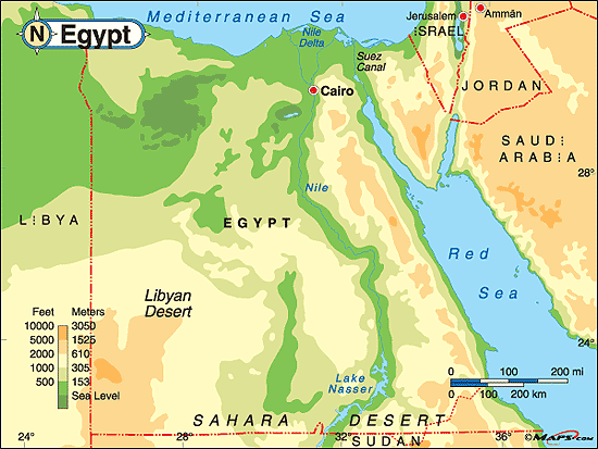
The lowest point of elevation in Egypt is the Qattara Depression which is located in Northwest Egypt and considered a part of the Libyan Desert. It is 436 feet below sea level.
The highest point of elevation in Egypt is Mount Catherine which is on the Egyptian Peninsula. It is 8,625 feet above sea level.
The highest point of elevation in Egypt is Mount Catherine which is on the Egyptian Peninsula. It is 8,625 feet above sea level.
Latitude and Longitude
Egypt's latitude is 26.0000° N, 30.0000° E.
Winter/Summer Season
Although Egypt has all four seasons, the transitions of Fall and Spring are barely noticeable, and the weather seems to reflect only Summer and Winter, which are the exaggerated seasons. In the Summer there is no precipitation, and very little wind, which leads to hot summer days and warm summer nights. During the Winter is when the most precipitation occurs, and wind also picks up, which leads to warm days and cool nights. There is also occasional frost in the Winter.
Annual Temperature
In the Coastal regions of Egypt the annual temperature reaches a maximum of 99° fahrenheit, and a minimum of 57° fahrenheit.
In the Desert regions of Egypt the annual temperatures reach a maximum of 114° fahrenheit (during the day) and a minimum of 42° fahrenheit (after sunset). During the Winter, temperatures in the Desert regions often go down to 32° fahrenheit.
In the Desert regions of Egypt the annual temperatures reach a maximum of 114° fahrenheit (during the day) and a minimum of 42° fahrenheit (after sunset). During the Winter, temperatures in the Desert regions often go down to 32° fahrenheit.
Precipitation
The coastal regions have the most humidity and therefore have the most rainfall ( 200 mm). The Desert regions have much less rain, in fact, some places can go years without any precipitation occurring. Cairo is one area that is almost in between these two regions, and it gets about 29 mm of rain yearly.
Proximity to Land or Water Forms
The Nile River is the world's longest river (4,000 miles) and starts in Ethiopia and ends in the Nile Delta, which flows out to the Mediterranean Sea. It is located in the far eastern part of Egypt, flowing from south to north.
The Sinai Peninsula is a strip of land that separates the Red Sea and the Mediterranean Sea.It is located in east Egypt.
The Red Sea is the sea to the east of Egypt, it is also underneath the Sinai Peninsula. The Mediterranean Sea is the sea north of Egypt. It is also the sea that the Nile Delta streams into. These two seas are both known for giving warm ocean currents that cause coastal strips on the north and east sides of Egypt.
The Nasser Lake is a man made lake that was created in 1958-1971 after the Aswan High Dam was created. It is located in southern Egypt.
Most of Egypt is made up of deserts, in fact about 2/3rds of Egypt is predominantly deserts.
Ocean Currents
Egypt is in the southern hemisphere, which is known to have warmer temperatures. Egypt is also located in between the Mediterranean Sea and the Red Sea, both of which give off warmth. Therefore, Egypt has warm ocean currents.
